From the app
Real briefings, not mockups
Live captures from FlyHedral Weather — an airport dashboard and a full route briefing, exactly what you'd see before a flight.
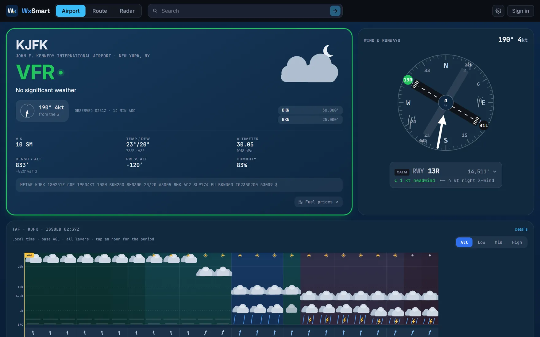
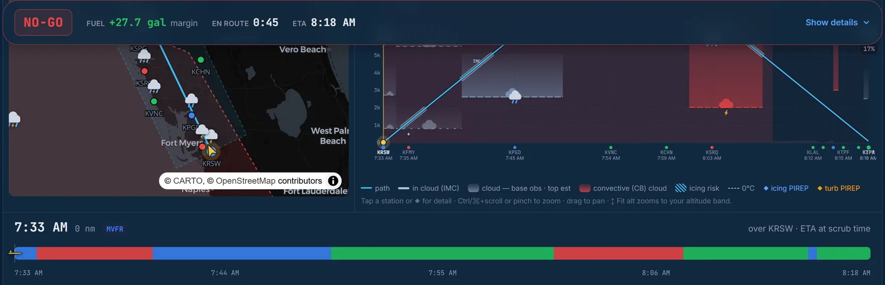
FlyHedral Weather reads METARs, TAFs, winds aloft, and hazards along your route the way a briefer would — in order, timed to when you'll actually be there — instead of leaving you to piece it together across five browser tabs. Check one airport, or brief a full route.
Not an official weather briefing. Always brief with Flight Service — 1-800-WX-BRIEF (1800wxbrief.com) — before you fly. It's a free FAA resource worth protecting: the more pilots use it, the longer it stays. You're PIC — the go/no-go is yours.
Live captures from FlyHedral Weather — an airport dashboard and a full route briefing, exactly what you'd see before a flight.
Check a single field's dashboard for the full picture, or lay out an origin, destination, and any waypoints and get a corridor briefing timed to when you'll actually be there. Both roads land on the same thing: a plain go/no‑go.
Search any of ~49,000 airports by ICAO, IATA, name, or city — or lay out a route with an aircraft profile (true airspeed, climb/descent, fuel burn) and a departure time.
Every checkpoint is briefed for the time you'll actually be there — TAF first, then the NWS point forecast, then the most recent METAR — with groundspeed and freezing level pulled from real winds‑aloft data.
SIGMETs, G‑AIRMETs, and PIREPs plot along the corridor, filtered to your actual altitude band, so a high‑altitude icing layer doesn't red‑flag a low VFR hop.
"I got tired of tab‑hopping between the raw METAR, the TAF, winds aloft, and the SIGMET page just to answer one question — should I go? WxSmart reads it back in the order a briefer would, timed to when I'll actually be there, and tells me straight: go, or no‑go."
Every tile decodes something a briefer would tell you out loud — nothing here is decoration.
Flight category, decoded METAR/TAF with hover tooltips, a wind compass with per‑runway head/cross/tailwind and a best‑runway pick, cloud layers with a ceiling marker, density/pressure altitude, and 12‑hour trend sparklines.
Full‑viewport radar reflectivity with a time‑loop playback over the last 50 minutes, opacity control, and flight‑category airport dots — or a collapsed radar tile right on the airport dashboard, centered on the field.
Lay out an origin, destination, and any waypoints with a configurable corridor width, and get every airport inside it briefed together — on a map, a climb/cruise/descent profile, and a checkpoint table.
Each checkpoint is briefed at the moment you'll actually cross it, not right now — a draggable departure‑time control re‑times the whole briefing instantly, no refetch, sliding hazards and PIREPs in and out as the clock moves.
SIGMET and G‑AIRMET icing/turbulence bands, plus PIREPs, plot along the corridor — filtered against your actual flight envelope, so an icing layer sitting above your cruise altitude doesn't false‑alarm a flight that will never reach it.
A GO / CAUTION / NO‑GO verdict checked against your own personal minimums — VFR or IFR rules, and a route‑vs‑destination scope so a marginal station along the way doesn't bust a flight into a clear field.
Enter burn rate, usable fuel, and a reserve policy and get time en route, a trip/taxi/reserve breakdown, margin over reserve, and range — with the reserve policy aware of day vs. night at your destination ETA.
Ground conditions, then the forecast, then what's between you and the destination, then the verdict.
No setup — pick an airport or lay out a route and the briefing builds itself.
Look up any airport by ICAO, IATA, name, or city — or start a route with an origin, destination, and any waypoints.
Pull a saved aircraft profile or one of the built‑in GA types for TAS/climb/descent/burn, then set when you're leaving.
Corridor‑filtered stations, timed to ETA, with hazards and winds aloft laid out checkpoint by checkpoint.
A plain GO / CAUTION / NO‑GO against your own minimums — or slide the departure time to find a better window.
I'm Russell — a working CFI. I'm at the airport most days, teaching real students in real airplanes, and dealing with the same weather, checkrides, and paperwork as every other instructor and pilot.
FlyHedral didn't start as a company. Every one of these tools began as something I built for myself — because I needed it that week, for my own flying or my own students, and nothing out there did the job the way a pilot would want it done. Once they made my flying easier, keeping them to myself felt wrong.
So that's what FlyHedral is: the tools I actually use, built by someone who's still out there flying and instructing — not a software company guessing at what pilots need.
Search any airport for the full dashboard, or lay out a route and get every checkpoint briefed at your ETA — ending in one clear verdict.
Open Weather →Sign in to save routes, aircraft profiles, and personal minimums across every device.